Shrubs
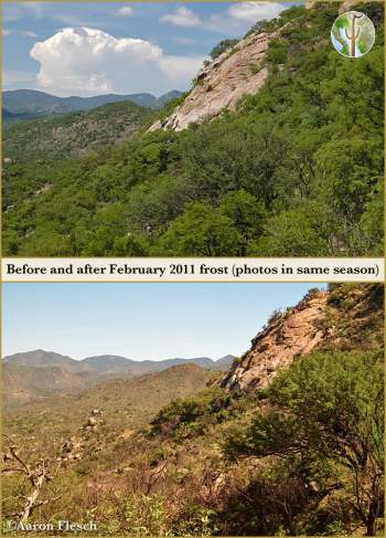
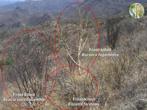
Thornscrub before and after heavy February 2011 frost
These photos were taken by Aaron Flesch before and after the February 2 and 3, 2011 frost. This unusually severe frost event was the worst freeze seen across Sonora and Arizona at least 50 years. Many species and vegetation communities were heavily effected.
These photos were taken in July 2009 (top) and July 2012 (bottom). One can see dramatic changes in vegetative cover in the foreground, as well as on hill-slopes in the background.
Vegetation and Wildlife Survey of Devil’s Canyon, Tonto National Forest (July 2007)
Devil’s Canyon is located in Pinal County Arizona a few miles east of Superior in the Globe Ranger District of the Tonto National Forest. The area is extremely rugged with deep canyons, rocky ridges, and uplands dominated by large boulders and towering spires. Pyroclastic welded tuft is the most common substrate throughout the area and creates beautiful cliffs, arches, and towers.
Vegetation and Wildlife Survey of Devil’s Canyon (Gaan Canyon), Tonto National Forest (May 2009)
Devil’s Canyon is located in Pinal County Arizona approximately 6 km east of the town of Superior in the Globe Ranger District of the Tonto National Forest. The area is generally rugged with deep canyons and is defined by its complex rock formations. Portions of Devil’s Canyon have stretches of large and dense riparian growth that support a high diversity of breeding birds and other wildlife.

