Off the Wagon and On the Whiskey Trail in the Sonoran Hinterlands
by Michael Huckaby
COWBOY COUNTRY
 Sahuaripa sits nestled against the foothills of the western flank of the Sierra Madre Occidental. It is at the north end of the valley of Tacupeto on the north flowing Rio Sahuaripa just before it enters the Rio Yaqui. This is cattle country. Some agriculture exist where farmers have taken advantage of the rivers leaving the sierras, but mostly it's cattle country. It's a tradition that goes back some 400 years, to when the Opata Indians were displaced by Spanish missionaries and miners. Cattle were introduced to feed the workers.
Vaqueros ride these hills in full length thick leather chaps to protect themselves in the thorn forest. Plants like vinorama, catclaw, and canyon hackberry vie for the opportunity to draw blood. The cattle get into some pretty difficult situations. To keep them safe is tough work with little pay, but it's a family tradition.
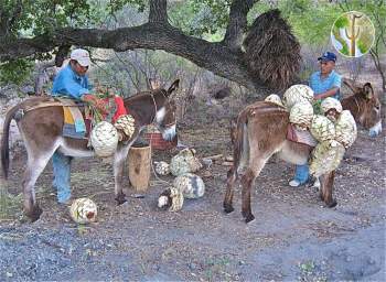
In the fall, there's a revival of another longstanding tradition. It starts when the first cool breezes signal the end of summer. The vaqueros sharpen their machetes and hatchets and harvest the fruits of the agave plants for the local moonshine called Bacanora. The production was legalized in 1992, but it's still made by small groups in remote locations using age-old, tried and true equipment. In fact the most modern contraptions at the vinata are the 55 gallon barrel and copper tubing.


